Sunday, August 05, 2012

Item From the Past: Old Faithful

Seven years ago, I wrote: "Naturally we visited Old Faithful. Gotta go see Old Faithful, and wait for it to fulfill its impressive duty, which it did for us at about 6:45 pm on August 5, 2005, pretty much as the rangers predicted — at the information booth, they wrote an estimated time of eruption on a little whiteboard. I also saw it on chalkboards at other places around the geyser."


Do kids hear about Old Faithful in school any more? I think -- and I'm in no way certain -- that we discussed the geyser in second- or third-grade class, maybe because of an article in our Weekly Reader. (I'm certain that's where we heard about the exciting prospect of a new Disneyland in Florida.)

Then again, maybe I first heard of it from "Tweety, Tweety, Tweety," the Looney Tunes cartoon in which Tweety moves forward the hands of the clock predicting the next eruption of an Old Faithful-like geyser, causing it to spit out Sylvester with some force.

Labels: ,

Sunday, May 13, 2012

Item from the Past: Zion NP

Zion Canyon at Zion National Park, May 2000.

To get a sense of scale, note the people standing on the trail near the bottom of the picture. A fine walk along a river that, I assume, created the canyon in the fullness of geological time.

At one point, the river was shallow enough so that we could stand in it and only get our feet wet. Lilly, who wasn't yet three at the time, was eager to do so, and spent more than a few minutes picking up stones from the water and throwing them back in. The majesty of the canyon didn't impress her, but those rocks sure did.

Labels: , ,

Wednesday, February 08, 2012

Cavern Inn '72

The ultima of our family trip in the summer of '72 was that classic destination, Carlsbad Caverns NP. The cave was impressive, of course, but I was 11, so just going to stay in a motel somewhere was fun. We ended up at the Cavern Inn Motel in Whites City.


The back of the card is incredibly busy, with bullet-pointed lists of motel amenities (including "clean mountain air" and "sky ride to Indian Cliff House"), information about the national park (hours and admission), and a map. There's barely any room to write a message on the oversized postcard.


I was glad to learn that Carlsbad Caverns charged $1.50 admission at the time for everyone over 16, which means my visit didn't cost anything. These days, over 15 admission is $6 for admission without a guide, which is what I think we did, so in real terms cave admission is cheaper than it was in the early '70s, since $1.50 in 1972 equals about $8 now. That's assuming the card wasn't that old when we got it, which is a fair bet since it's got both a zip code and an area code on it, and besides, look how important orange and aqua are to the color scheme.

Labels: , , ,

Sunday, July 31, 2011

Item From the Past: Yellowstone '05

It's been six years since we drove in late July/early August to Yellowstone NP and other western points. How do the years escape like that?


Here are Lilly and Ann, looking a lot smaller, on the banks of the Gardner River, a tributary of the Yellowstone.


Then I turned and looked southward at the river.


The current was gentle, and we were able to wade into the river, which was shallow and rocky at this point. As I discovered by spotting a US Geodetic Survey marker nearby, we were only a few feet north of the Montana-Wyoming state line, which is also the 45th parallel of latitude north.


This is the venting, sulfurous Yellowstone famed in tourist lore.


I think I took this shot at the Norris Geyser Basin, which is traversed by long boardwalks, with plenty of signs warning visitors not to stray onto the terrain or risk being boiled alive.


Less hellish is the cool Isa Lake, a small body of water in the park with the distinction of straddling the Continental Divide, which at that point has a elevation of 8,262 feet.


Isa Lake (wouldn't Lake Isa sound better?) thus drains into both the Pacific and Atlantic oceans. According to Wiki, citing pages I can't access tonight, "the east side of the lake drains by way of the Lewis River to the Pacific Ocean and the west side of the lake drains by way of the Firehole River to the Atlantic Ocean. This is the opposite of what one would expect, since the Atlantic Ocean is east of the lake and the Pacific Ocean is to the west."

Labels: , ,

Sunday, March 27, 2011

Item From the Past: Mt. Fuji & T-Shirt

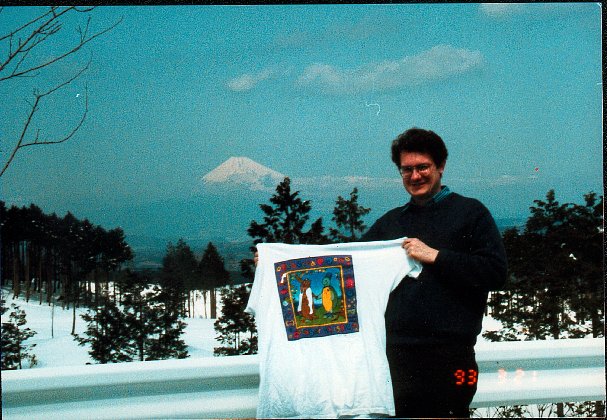
This is about as close as I ever got to Mt. Fuji, during a short visit to the area around the spring equinox in 1993. The remarkable thing was that the peak was actually visible, rather than obscured by clouds.


A short while before, a graphic artist friend of mine created a t-shirt to commemorate her wedding, and she sent one to me (note the cartoon characters holding hands). I told her in a fit of exuberance that I would have pictures made featuring the shirt in famous places, and send her copies. This was one of the first such pictures, if not the first, and I made a few others, but eventually the notion fell by the wayside.


A decade later, I received a Route of Seeing cap from Ed, and not-quite-seriously had the idea to do the same as with it as with the wedding t-shirt. Except now, in the age of digital photos and e-mail, it would be much easier to send him the images. During our trip in '05, whose ultima was Yellowstone NP, I managed to take a few pics featuring the cap.


The next year, I took it to Canada and documented its visit with a few more pictures. The cap seemed to have a penchant for continental divides.


And then I lost the cap.

Labels: , , ,

Sunday, July 11, 2010

Item From the Past: Canadian Waters

In July 2006, after visiting Moraine Lake and the Valley of the Ten Peaks, in Banff National Park in Alberta, I bought a postcard that depicted the famed vista below (which is my own photo, not the postcard's image) and sent it to my old friend Ed, who's well acquainted with the Canadian Rockies. On the card I wrote only: "Oh My God!"


Next is an image of the Columbia Icefield, on the border of Banff NP and Jasper NP. This vantage looks like we might have taken ice axes in hand and adventured our way up the icefield to reach this point, but of course we didn't. There's a bus that goes on to the icefield, and specific places you can wander around it without much risk.


Some miles to the north in Jasper NP is Athabasca Falls. It isn't known for its height, which is about 80 feet. But it's got power. All of the Athabasca River rushes to the precipice and drops over. The river's in a hurry to reach the Arctic Ocean.


Labels: , ,

Sunday, May 16, 2010

Item From the Past: Death Valley Day

In May Death Valley National Park sees an average daytime high of 99° F. (37° C.), according to an easily accessible climate chart, and I believe it. We piggybacked an afternoon excursion to Death Valley onto a trip mainly involving my attendance at a convention in Las Vegas in May nine years ago. I would have picked February or March for Death Valley, maybe, but the convention organizers didn't ask me.


I'm pretty sure this is the Elevation Sea Level sign on California 190, just inside the park.


It's hard to see, but the white sign fixed to the top of the green sign says Park Off Pavement. Maybe there'd been a persistent problem with people taking pictures like this one without bothering to pull all the way off the road, a safety hazard even on a desert road.


Near Furnace Creek inside the park is the Harmony Borax Works Interpretive Trail. Outdoor.com tells us that "the... trail takes visitors around the ruins of a borax processing plant that was active during the 1880s. This historic site is approached by an easy 1/4 mile paved path from the Harmony Borax Works parking lot located one mile north of Furnace Creek on Highway 190. The trail loops around the ruins of the 1800s processing plant."


At near 100°, the trail would not be so easy, especially with a three-year-old in tow, so we didn't walk it. I did take pictures, though.


At Badwater Basin, the water does look pretty bad, though Wiki claims that the pool supports pickleweed, aquatic insects and the Badwater snail. The parking lot next to the pool isn't actually the lowest elevation in North America; some slightly lower spot is off on the salt flats somewhere. But it's close enough for me.


Badwater Basin also one of the termini of an annual race by lunatics. According to Badwater.com: "AdventureCORPS Inc.... hosts the Badwater™ Ultramarathon annually in July of each year. Recognized globally as 'the world's toughest foot race,' this legendary event pits up to 90 of the world's toughest athletes [those would be the lunatics] against one another and the elements. Covering 135 miles (217km) non-stop from Death Valley to Mt. Whitney in temperatures up to 130F (55C), it is the most demanding and extreme running race offered anywhere on the planet."

Labels: , , ,

Sunday, May 17, 2009

Item From the Past: Arizona Days

May 17-19, 1997.

Saturday: The big event of the day was going to Boyce Thompson Arboretum [photo below], about an hour’s drive southeast of Phoenix (Ed drove). It was hot as we walked through it, looking at the multitude of desert plants, plus lizards and other small fauna, but there was a fair amount of shade. After we returned to Phoenix, we had a late lunch at an inexpensive steak/Mexican/Southwestern restaurant built on the site of a hacienda and flour mill on the Salt River, which was bone dry.


Sunday: In the early afternoon we picked up Mama at Sky Harbor Airport — I think it’s a funny name — and soon embarked on a drive northward. We took the Interstate to Flagstaff, passing through but not stopping there, and then took Arizona 89 to Cameron, about 25 miles from the eastern entrance of Grand Canyon Nat’l Park and just inside the Navajo Reservation. Along the way we stopped at Montezuma Castle National Monument, a cliff dwelling built and inhabited by the Sinagua Indians around A.D. 1100, and having naught to do with the emperor of the Aztecs. Nothing like a desolate ruin to enlarge your day, as it whispers memento mori in modern man's ear.


We checked into the Cameron Trading Post Lodge, a complex of very comfortable and well-appointed rooms, a lovely garden, an enormous gift shop and a restaurant. The rest of Cameron seemed to be mostly small trailers spread out on the arid landscape. Since we’d arrived late in the evening, we had dinner at the restaurant. Three of us had a thing called a Navajo taco, which was much like a taco except that “Navajo frybread” was used to hold the ingredients. A regular one of these was enormous. The frybread was the best ingredient.


Monday: A day at the Grand Canyon. After breakfast at the motel restaurant (not bad) we headed west to the canyon, stopping first to see it from Desert View [pictured below]. It was the first of many views we stopped at.


Later, after arriving at the park headquarters, Mama and I hooked up with a tour of the town of Grand Canyon’s cemetery, which has a number of pioneers and miscreants of early canyon times within, as well as a memorial to the two airplanes that collided over the canyon in 1956. Yuriko wasn’t feeling so well then, and doesn’t care for cemeteries anyway, so she sat it out. After the tour, we started to look for a place to have a picnic (we’d brought food), and it started to rain while we were at a shopping complex near the headquarters. Yuriko says that that complex didn’t exist when she was there before, in 1990. So we ate at a picnic table facing the parking lot, under an extension of the roof of the stores.


But it was a short rain, and soon we were walking the South Rim trail, taking in some more views. After about a mile of this, we wanted to take a shuttle back from near the Teddy Roosevelt-era hotel whose name I forget, but couldn’t find the stop, so we walked back. But that time we were plenty hungry, and discovered a cafeteria across the parking lot from where we’d had lunch. It was reasonably good and not too expensive — a marked change, Yuriko said, from the last time she was there, when buying food at the canyon meant getting gouged. We didn’t finish dinner that evening till after dark, which meant driving back to Cameron on the narrow and reflector-less park roads. It was a long few miles.

Labels: , ,

Friday, July 18, 2008

Et Cetera, Et Cetera, Et Cetera

Outside Lafayette, Indiana, I spotted a white pickup with large red letters painted on the side: Jesus Christ is Lord, Not a Swear Word.


Later, during a brief traffic jam, I noticed that a different pickup, ahead of us, had a couple of metal orbs hanging from its towing hitch. Though a little larger than natural size, these orbs strongly resembled human balls. Some people wear their hearts on their sleeves. Not this chap.


At some distance from Louisville, we picked up WNAS, 88.1 FM. Its music selection was all over the place, but mostly good. Turns out it's a high school radio station with more power than most. If the the idea is to teach students about the radio business, such an eclectic format isn't going to cut it. On the other hand, real-world, for-profit radio formats tend to be as bland as slim milk, and running a student radio station that way would be no fun at all.


I saw a White Castle in Nashville. This is wrong. Nashville is south of the invisible White Castle-Krystal line. Nashville is Krystal (makes noise when opened) territory. I can understand Kentucky having both, since it's a border state, but not Tennessee.


The Elliston Place Soda Shop in Nashville is still in business. In fact, it looks very much like it did in the 1980s -- which probably wasn't so different than in the 1940s. When I first took Yuriko to Nashville in late 1992, we had milk shakes there. She remembered that milk shake so fondly that she insisted that we go again this time for more, and I hardly needed persuading. Someday, it will close -- sic transit gloria mundi -- and Nashville will be a poorer place for it.


Nashville's already a poorer place for the demise of Mack's Country Cooking, a meat-and-three (there's a web site for everything, eh?) I visited often, alone and with greasy-spoon companions. But at least the San Antonio Taco Co. survives, serving real South Texas Mexican food. We had lunch there this trip, and it's as good as it was 20+ years ago, which explained the crowds on a summer afternoon in 2008.


Centennial Park in Nashville, besides sporting the world's only full-scale replica of the Parthenon, now has a lovely little garden not far from that edifice. It is dedicated to children who die from domestic violence, with some of their names carved in stone along the brickwalk.


Sparta, Tennessee, advertises itself as the home of Benny Martin. Sounded familiar, but I had to look him up later. The Calfkiller River also runs through Sparta. I had to look that up, too. It's a tributary of the Caney Fork, a tributary of the Cumberland, and I like that name as much as Fawnskin, Calif.


The mosquitoes weren't so bad at the Crosby campground in the Great Smoky Mountains NP. But arachnophobes would have had a hard time at the campground bathrooms, which featured cinderblock walls. Close inspection revealed a good number of orange daddy-long-leg-type spiders hanging out on the walls, doing their silent little dances. Once you noticed them, you couldn't un-notice them. A lot of moths also called the park home, and some number of them wanted to call the inside of our tent home. Ann was alarmed at the prospect.


This is the Appalachian Trail as it reaches Clingman's Dome. An old friend of mine hiked the entire thing 20 years ago this year, a feat I greatly admire.


It rained on us only twice during this trip. Once was while we were touring Mammoth Cave, on June 28. When we emerged, water was pouring through rivulets into the cave entrance, and on the hillsides near the cave. On the Fourth of July, it rained near and in Frankfort, Ky., causing us to opt out of the municipal fireworks show.


This is a creek (crick) in the Smokies. The girls enjoyed it immensely.


This is a waterfall above a crick on Cherokee land, just outside the national park. The girls enjoyed this immensely as well.


This is Mingus Mill, just inside the park. In the days when it ground grain, it was powered by water diverted from a nearby crick, and though now an exhibit, the water still flows. The girls found a way to enjoy this immensely too, by standing next to the water trough and putting objects in the water -- leaves, twigs, even small rocks -- and watching them zip away on the fairly fast current.


The Biltmore house has a vast collection of fine art, elegant furniture, and historic artifacts set in an interesting layout among a lot of fascinating detail. My favorite room? The bowling alley in the basement. My favorite item? Napoleon's chess set.


Besides the capitol, there are many other historic structures in Frankfort, Ky. On one block is the home of John Crittenden -- a footnote character in American history. President-elect Zachary Taylor stayed at Crittenden's on his way to his inauguration in 1849. Ever the busy fellow, Taylor stayed at nearby Liberty Hall as well, whose guest list over the years also included James Monroe and Andrew Jackson. The building itself was closed, but there was a lush little garden in the back yard, full of flowers and their bee and butterfly attendants. No other people were around.


In the parking lot of a chain restaurant in Morristown, Tennessee, a stranger asked me for money -- enough to fix her car, she said. A skinny blonde woman in her 30s, she talked with a deep Southern accent at an incongruous high clip, so fast that Yuriko and Lilly both later said she couldn't understand her. In her rapid talk, she packed in a lot: her stranded kids, her broken car, other good Samaritans who had helped some, the incentive check that hadn't arrived. She referred to the Good Lord a few times, and held her pocketbook open in such a way that I could see the words JESUS SAVES clearly. I told her that we carried little cash, at which he suggested that I go with her to an auto parts store to buy the part. "I'm sorry, I can't help you," I said, and I must have sounded unmovable, because she was gone a few seconds later.


Con woman? I'm inclined to think so. If not, she suffered because too many people are con artists. Maybe she really was trying to get her car fixed, but without paying for it. Yuriko suggested that she would later find a man more partial to skinny blondes, and be able to con him. Maybe.


Unfortunately, we didn't have time to stop at Cumberland Gap National Historic Park. It would have been another Daniel Boone site to see. But we did pass through the Cumberland Gap Tunnel, nearly a mile long. Now that's a tunnel. It's also an example of a big public works project of the 1990s, which will probably not be remembered as a heyday of such projects.


Finally, we brought home a souvenir fly swatter from the Bluegrass Inn, Frankfort, Ky., because it says the name of the motel on it, along with "Complements of..." The motel was decent enough, though a little tired, and I like the fly swatter. But is a fly swatter really the best item to associate with your motel? Just wondering.

Labels: , , , , ,

Monday, July 07, 2008

The Roads Ahead

The best-known road that we drove last week was the section of US 441, also known as the Newfound Gap Road, that crosses Great Smoky Mountains National Park. It is a windy little road, ascending to a point near Clingman's Dome, Tennessee, and then descending into North Carolina -- or the other way around, depending on which way you drive it. Verdant beyond belief in early July, the road also has pretty much everything you'd want in a mountain road any time of year, such as winding switchbacks and access to various historic structures and hiking trails. Plus scenic overlooks. A lot of scenic overlooks; after the first few, you quit getting out of the car.


At about Mile 10 (I think), still in Tennessee, there's the Mother of All Switchbacks, a place where the road loops completely around and passes over itself -- or loops around and passes under itself, depending. The warning sign describing this particular bit of road topography is pictured here (see November 10) -- a memorable sign.


I'm astonished that the photographer got a photo of that sign at all, since stopping or pulling over on the Newfound Gap Road is risky business. While smooth (partly repaved in recent years, I read), most of the road has no shoulder, and traffic is heavy. The park is the most popular one in the entire national park system -- 9.4 million visitors in 2007, according to the National Park Service. One any given day in the summer, a large number of that total seems to be on Newfound Gap Road, which made for a number white-knuckle moments, especially at when traffic appeared three and four and five RVs deep on the other side of the road, just as you hit a switchback. Carefree highway, it's not.


Unsurprisingly, Newfound Gap Road passes through Newfound Gap, a location some distance lower than Clingman's Dome, the highest point in the park, but important enough that the dedication of the park was held there on September 2, 1940. The occasion was considered important enough that President Roosevelt himself came to speak, from a platform of stones built for the occasion by the CCC. A plaque marks the spot now; less obvious is the fact that the Tennessee-North Carolina border runs through the site. Through the plaque, I've read, which is a fitting bit of symbolism to mark the cooperation of the two states in putting the park together.


Ann took this picture of the place, with only a little help from me.


Interstate 40, which skirts the park to the east, has its own share of curves, along with enough mountainous landscapes to count as scenic. Like stretches of I-89 in Vermont or I-10 in Louisiana or the Mackinac Bridge, it makes the case that the Interstate system is not completely a bore.


In fact, a little bit more of a bore would have suited me. Along much of I-40 from the park to Asheville, trucks aren't allowed in the left lane, and are required to go slower than cars. The result was long lines of trucks in the right lane -- six or eight. Drivers of lesser vehicles, such as a dark green Sienna all the way from Illinois, either had to hang behind the trucks, or pass the trucks on the left, between them and the concrete barrier, through a couple of serious curves.


Despite their obvious dangers, I-40 and the Newfound Gap Road were good driving roads. Better, however, was a piece of the as-yet unfinished Foothills Parkway, tucked away just north of the park, connecting the town of Crosby, Tenn., with I-40. At five miles or so, it was an abbreviated Newfound Gap Road, with some similar scenery, but almost no traffic. An obscure gem of a road.

Labels: , , ,

Wednesday, July 26, 2006

Wapiti &c.

“You are now in a bear habitat,” a number of signs posted at Wapiti campground, a couple of miles from Jasper Townsite, said in English and below that in French. Also included were stern bilingual warnings about staying clear of bears, not feeding bears, etc., with the unwritten message being, don’t be a moron who mistakes real bears for Yogi and Boo-Boo.


We didn’t see any bears at Wapiti, though there were plenty of elk, which could also clean your clock if you acted threatening or weird in their vicinity. Elk or no elk, Wapiti quickly became my favorite campsite anywhere, edging out other favorites such as the walk-in site at Pete’s Lake in Michigan with its view of starlight on the lake or Bastrop State Park, which evokes a little high school nostalgia for me.


Wapiti’s an enormous wooded campground, 366 sites spread on a large piece of real estate between the road to Jasper Townsite and the Athabasca River. It’s also bounded on one side by a creek, which I later found out was called Whister’s Creek, and we got a site next to the creek that included plenty of tall trees and a flat spot among them just big enough for the tent.


We parked some folding chairs creekside, which made a fine place to read. It was rapid and rocky, meaning great sport for Lilly and Ann in stone tossing. Even better than any of that was the constant low rush of the water, recorded versions of which people pay money for. By itself it was soothing to fall asleep to, but it also had the bonus of drowning out noise from our neighbors on either side, who weren’t that near anyway. No distant caterwauling or radio noise from people who just have to have their Retro-80s! Superstation! Flashback! Weekend! playing in the middle of a national park.


The campsite at the North Unit of Theodore Roosevelt NP was shady and quiet, too, because there weren’t many people there. People go to South Dakota. People go to Yellowstone, Glacier and the Grand Tetons. North Dakota? I asked a park ranger about the low number of visitors, and she said yep, TR NP’s an unknown jewel of the park system. I agree.


A thunderstorm greeted us on our arrival in that part of North Dakota. We’d started the day, July 12, in a motel in Medicine Hat, Alberta, and didn’t particularly make haste on the drive that took us back across part of Saskatchewan and into North Dakota. By the time we stopped for gas in Williston, ND, it was almost dark and we could see an angry-looking storm off to the east. Just the thing you want to see when you’re planning to pitch a tent not far away, to the southeast.


But we pressed on, and the darker it got, the more terrific the lightning became. The country around there isn’t completely flat, but it’s flat enough to let you see for miles—boiling dark clouds lit up by bolts. Best lightning show I’d seen in years. The girls were so scared they covered themselves up with a blanket. So scared they actually shared the blanket without argument.


Sleeping in the car wasn’t something I really wanted to do, since I have long legs, and as soon as we got to the campsite, I put up the tent as fast as I could. It rained a little but mostly I had lightning and thunder to content with. There were trees around, and the time between the flash and the rumble was fairly long, so I figured I was fairly safe. We piled into the tent and listened to more thunder and watched everything light up with spooky blue lightning light for a while. When we woke up the next morning, the sky was clear and the ground wasn’t wet.


After our very first day of driving, the long Schaumburg to Fargo run on July 1, we arrived at Lindenwood Park, which is along the west bank of the Red River of the North just across from Moorhead, Minn. It’s a Fargo municipal park, and yet has campsites, a couple of rows for RVs near the river, and space for tents right on the river. I’d called ahead a couple of weeks before but was told that the tent sites had flooded. “It’s been raining a lot here,” the attendant said.


So I wasn’t sure we’d be able to camp there, but the river was down by the time we got there, so we got a site for a reasonable $12.50 a night next to the river. It didn’t have a picnic table, so we took (and cooked) our meals on the ground. Not many rocks were at hand to throw in the river, so the kids pried loose pieces of earth from a nearby spot that had been flooded, then dried and cracked, and used those. We had some mosquitoes, but not as many as I would have thought.


Our neighbor was a minor pest, though. A wiry, grizzled fellow in his 50s who was bicycling long distance, he was eager to make conversation, beginning while I was putting up the tent, including almost immediately oblique comments on my skills at it. “So this is the first time you’ve put up the tent, huh?” I might have answered him as a younger man, but I didn’t bother, especially since I was busy actually putting up the tent at the time. (The answer: I’d put it up in Illinois, Wisconsin, Michigan, Minnesota, South Dakota, and Montana, all successfully enough to shield my family from rain and wind and bugs.)


Later conversations with the man, which luckily weren’t that extensive, made me think he was just one of those people who had a knack for saying mildly irritating things, probably without realizing it, so I won’t be too hard on him. Still, like the Red River mosquitoes, I wasn’t sad to leave him behind.

Labels: , , , , , ,

Sunday, July 23, 2006

Fauna

The only creature I run into regularly while camping is one or another kind of mosquito. The weather had been dryish in Jasper NP, so there weren’t that many there. Things had been even drier at Theodore Roosevelt NP, and we encountered only a very few hardy mosquitoes who managed to survive wrigglerhood in the risk-of-wildfire badlands this summer.


The plains near Regina, Saskatchewan, were another story. On the evening of July 3, we found a private campground a few miles east of Regina for a reasonable C$14. The place was sparse with people, probably since the Canada Day long weekend was winding down, but well populated with blood-drinking vermin. Their main diet likely came from the livestock on the surrounding ranches, but they weren’t above snacking on human beings. Once a cloud of them followed me, so I had to zig-zag back to our camp to lose them. Others buzzed intensely around the tent door until I sprayed it with Off.


Prairie-dog town hardly describes the colonies we saw next to the single road in the South Unit of TR NP. A couple of prairie-dog cities is more like it, with suburban prairie-dog sprawl thrown in. The more you looked, the more of them you saw, and the more holes in the ground you saw. I understand that some prairie dogs act as guards for the colonies, and I believe it too. One little fellow eyed us pretty closely the entire time we were admiring his hometown.


Elsewhere in TR NP we came across the small group of wild horses which, contrary to popular image of creatures spirited and running free as the wind, looked pretty much like any saddle- and bridle-less horses eating grass. The difference, I guess, would be in what they do when people come near. We didn’t get near enough to test this, but I suspect that they would behave like most wild animals and get the hell away from people.


On the morning of July 13, we took in a ranger presentation about buffalo, near our campsite (at the amphitheater, as park literature called it—a collection of benches facing a table). Fairly interesting, especially right at the end, when a bull bison wandered by, as if on cue. He showed no interest in us.


We saw buffalo elsewhere in the park from time to time, mostly lounging around on hillsides. That’s the life. No Indian nor white hunters to worry about, though the ranger did say that every few years the Park Service culls the herds of its older and more infirm members, taking the part of buffalo predators that no longer roam the park. So it’s the life of Logan, sort of.


And I don’t care what zoologists and park rangers say. I plan to use American bison and buffalo interchangeably. Those creatures are buffalo, and they can share the name with bovines in Asia and Africa without confusion. The U.S. minted buffalo, not bison, nickels from 1913 to 1938, and it’s buffalo soldiers, buffalo wings, and Buffalo, NY.


Back in Jasper NP, we saw a lot of elk. We stayed in a campground called Wapiti, which I’ve read means “elk” in Shawnee, and that was a fitting name, because they wandered through every day we were there, sometimes picturesquely (to us) next to the fast-flowing Whistlers Creek.


In Kootenay NP on July 6, we stopped for a walk to the Paint Pots, where iron-rich springs bubble up through small pools, coloring the surrounding ground a Georgia orange, or, as the guide signs call it, ochre. Apparently both Indians and white men used the pigmentation in pre-park days, with some of the latter’s mining tools still littering the site. At the end of the trail, a couple of near-circular pools were a remarkably gaudy green, because of certain other minerals within (I forget what).


On the return, Yuriko and Lilly went ahead of Ann and I, because Ann’s easily distracted, and because Lilly wanted to go back to a riverside and throw rocks. En route, Ann and I sat on a bench facing a stretch of pools and ochre ground. Behind us were some woods.


Ann was standing on the bench looking back into the woods when she said, “Bear. Bear. Look!”


I looked, and about 100 feet away was a black bear, standing up and looking at us. About a second later, he turned away and disappeared.

Labels: , , , ,

Tuesday, July 18, 2006

Banff v. Jasper

Before we left for Canada, I consulted with a friend who knows the Canadian Rockies well, and regarding Banff Townsite, which is in the national park of the same name, he used the word, “nightmare.”


I’d already planned not to stay in the town of Banff, warned by other sources about crowds and the high cost of accommodation in summer. Instead, to explore Banff NP, we spent three nights at a motel, the Drake Inn, in Canmore, a town just outside the park’s boundary to the south. The Drake was decidedly plain, but had a delightful location along Policeman’s Creek, which runs through the town and which has a plank walkway on one of its banks—not a wilderness walk in any sense, but a pleasant morningtime stroll among pines and twittering birds and the gurgle of a creek.


Canmore had its shopping street, partly living off tourists, but it was still a fairly sedate place. Banff Township was not. “Nightmare” might be too strong of a word, but after an hour or so on the teeming sidewalks of Banff, a town saturated with retail space, I was ready to leave. Several streets in Banff not only feed off out-of-towners, but cater to the sort of person who considers shopping an essential part of any trip, or who might even travel just to shop someplace new. I won’t mock that sort of mindset (though I’m tempted), but I certainly don’t share it, and Yuriko doesn’t either, at least not much.


But there was something in Banff both Yuriko and I did want to see: the Banff Springs Hotel. You can’t very well come to Banff NP and not see it. That would be like going to Singapore and passing on the Raffles.


So we went into Banff Townsite and sought out the hotel, one of the grand old railroad hotels of Canada, and actually part of the reason Banff eventually became a national park. The railroad and its hotel were instrumental in bringing people to the area in the early days, many of whom no doubt help shape Canada’s parks policy in the early 1900s.


It’s an impressive pile o’ stones indeed, particularly the backside, which commands an extraordinary view. Canned histories of the hotel would have you believe that the builders got it backwards, and that the front should have faced the mountain vista, but I don’t think so. The entrance is the workaday side of a hotel like this. The back is where guests can lounge around and soak in the view.


Later, we spent time at Jasper Townsite, the main town in Jasper NP, a much more likable place than Banff. Both are ringed by forests and mountains, but Jasper feels more remote. Which it is, since it’s further from the Trans-Canadian Highway than Banff. It’s also smaller, less crowded and really has only two shopping streets, the main drag Connaught Dr. and the parallel Patricia St. Jasper reminded me of Flagstaff, Ariz., because both towns have a main street fronted by businesses on one side and by a rail line on the other, complete with a railroad station—a fine old restored station in the case of Jasper.


But Jasper had more going for it than a passing similarity to Flagstaff. You might ask, who needs a town in a wilderness national park, especially when you aren’t even staying there, but camping a few miles away? A family of four does. In Jasper we bought groceries and gas and ice cream, ate a few meals, did our laundry, bought and mailed a fair number of postcards, and let the kids play at a well-appointed municipal park a few blocks from the main street, something that often interested them more than the prospect of walking another couple of miles in the woods, no matter how promising the scenery.


We also spent a short while at the town’s log-cabin visitor center, sitting around on its front-porch benching looking out onto a pleasant lawn and beyond that to the train station. On other occasion, I had the chance to wander around the back streets of the town by myself, and enjoyed the sight of two churches, both little jewels of construction, each set at 45-degree angles to their street—which was the same street, the curiously named Geikie St. Two blocks apart, it was almost as if the two church buildings were facing off: one Anglican, the other Lutheran.

Labels: , , ,

Saturday, May 20, 2006

Item From an Old Zip Disk

May 19, 2001

Death Valley Day. Our rental car for the trip was a maroon ’01 Oldsmobile. I figured I would take that one, since they aren’t going make them any more. It served us well. We didn’t leave for Death Valley right away, however, since other matters needed our attention — sleeping late, eating a large breakfast, going to the Aladdin pool.


Breakfast was at an off-Strip casino that I’d read about, Arizona Charlie’s. Now that was a Las Vegas breakfast. Everything on the Strip is a profit center. Elsewhere, loss-leader food is still offered, and the ham & eggs & hash browns & biscuit & tea I had was about $4, and tasty too.


We headed north in the early afternoon, a wise decision as it turned out, since by the time we were in the thick of Death Valley, the sun was going down, and temps were only in the 90s. Even so, that’s hot enough, and the trip was mostly driving, but fine driving, the kind with few cars and scenic mountains and flats.


The best part by far was the “Artist’s Drive,” a few miles of road near the park headquarters at Furnace Creek. Time had colored the cliff walls masterfully, and on that road the cliff walls weren’t far away — it snakes up and down and within a few feet of the rocks. We also spent a few minutes at the side of the road at Badwater, which is reportedly the lowest point to which you can drive in the Western Hemisphere, and only two feet higher than the nadir of the hemisphere, out on the salt flat where only the foolish roam in May. If you look carefully, you can see on a mountainside near Badwater a sign 220 feet up that says “sea level.”

Labels: , ,

Saturday, August 20, 2005

Four Faces

I got a short sideways look at the profile of the Crazy Horse Memorial in the Black Hills, as we drove by on US 16/385, and it looked impressive indeed. A fine monumental project. Why didn’t we stop? Price for a carload of visitors: $24. I would have paid half that, I think. Whoever’s in charge of the sculpture needs to raise money, but I refuse to be gouged for the cause.


Besides, we were on the way to Mt. Rushmore that evening, and the sun was going down. We wanted to see the iconic mountainside by day, and then after dark, lit from below. Speaking of gouging—or at least nicking—parking at the Mt. Rushmore National Monument costs $8. Not that bad, but my brand-new national parks pass didn’t cover the cost. Grumble.


The garage looked fairly new, a lot like the parking structure next to a mid-sized regional airport. A couple of stairways out of the garage lead to fairly new-looking tourist infrastructure, starting with a walkway that leads to a building complex—including a gift shop, near a large bronze bust of Gutzon Borglum by his son—that leads to another walkway flanked on both sides by structures (too bulky to be poles) flying the flags of all the states in groups of four. Four doesn’t divide evenly into 50, so perhaps DC and Puerto Rico are included, but I didn’t check.


From there, you reach another building, which also includes a gift shop, past which is an amphitheater. All the way, though, the Mt. Rushmore sculptures are visible. Despite the fact that the Four Faces are seen in countless photos, drawings, cartoons and North by Northwest, the sculptures capture and hold the eye. Yuriko, who didn’t grow up with iconic Mt. Rushmore, was just as impressed, if not more. Later she said she used to wonder why anyone would deface a mountain in such a large way, but after seeing it she called it great art.


I hope Simon B. has had a chance to see Mt. Rushmore in person. He was an erudite young Englishman I knew in Japan in the early ’90s. I forget how it came up, but once he suggested that Mt. Rushmore was a vast act of vandalism. When I heard that—which sounds like a lump from the oatmeal of anti-Western Civilization diatribes, trying to pass as an idea--I decided I needed to shock him a little, so my comment was, “You know what? Even if it is, I don’t care.”


We sat in the outdoor amphitheater facing the Faces, along with hundreds of people, waiting for the lighting ceremony. By this time it was getting dark. An enormous bank of clouds loomed off to one side of the sky, dark and rumbling. Eventually, a park ranger—a woman no older than 30, I think—came out on stage and said the show was going to go on until it started raining. Rumble.


I wondered what the show would be. A laser show! A laser show to John Philip Sousa! A laser show, John Philip Sousa, and four presidential impersonators down on stage! No. The Park Service isn’t quite so showy. The young ranger talked for about 15 minutes, first about coming to see Mt. Rushmore as a kid, then telling the audience about the four presidents, as if anyone over about 10 didn’t know about them. Then again, maybe people don’t. Rumble. The clouds were a lot closer by now.


After she was done, the stage curtain opened. Rumble. Boom. BOOM. A Discovery Channel video about Mt. Rushmore started rolling on the amphitheater’s big screen. The beginning scenes were of the Dakotas, including a shot of distant lightning on the prairie. Off screen, real lightning flashed, and by this time the amphitheater was losing people, including us. Soon the video stopped, and it was raining. People shouted, “Light it! Light it!” for the Faces were dark by this time, except during lightning flashes.


Before long, the lights were on, and we were treated to a luminous Mt. Rushmore in the rain. Water traced down parts of the Faces, leaving dark streaks. In all the many photos of the monument I’ve seen, I’ve never seen it half-washed like that.

Labels: , , , ,

Friday, August 12, 2005

Borders

I’ll pick this up again on Monday, since I have professional obligations to take care of between now and then.


Late in the morning last Saturday we stopped to go swimming in the Firehole River, a tributary of the Yellowstone, by parallel parking along the narrow Firehole Canyon Drive nearby. From the drive, you go down some wooden stairs, and swim in a section of the river slowed — it’s very swift elsewhere — by a upstream narrows that empties into a deep pool, picturesquely surrounded by rocky cliffs on both sides. The current is also slowed by underwater rocks slightly downstream from the narrows. The water’s cold, the sun’s hot in August, and parts of the swimming area have a rocky bottom. But it was pleasant swimming all the same, especially after you discover spots with sandy bottoms. Lilly didn’t want to leave.


While parking the car, I noticed two guys behind us unloading scuba equipment out of a pickup truck. “Are you going diving?” I asked them as we headed for the wooden stairs.


“Yeah, the pool’s pretty deep,” one of them said. “We’re going to look around.”


Yellowstone offers a lot recreational opportunities, as the guide literature notes: hiking, cycling, camping, fishing, birding, swimming, cross-country skiing, and more. But scuba diving isn’t something I would have thought of. As we were swimming, I noticed several other divers going in and out of the deep pool, so there must be something to look at down there.


It wasn’t the only river we experienced firsthand at Yellowstone. Just south of the park’s north entrance, there’s a parking lot next to the Gardiner River. Just beyond the edge of the lot is a path that follows the edge of the river, under some shade trees. The river is very shallow at that point, with a cold current pushing over piles of very smooth stones. Like at Firehole, piles of rock moderated the current a little, so that you could sit in the river and let it wash over you. It wasn’t exactly swimming, but it was refreshing.


Along the road, just at the entrance to the parking lot, there were two signs: ENTERING WYOMING and 45TH PARALLEL of LATITUDE HALFWAY BETWEEN EQUATOR and NORTH POLE. I’d always thought it odd that Yellowstone National Park isn’t quite all in Wyoming, though most of it is — it’s as if the park couldn’t quite fit in Wyoming, so Montana and Idaho got slices. (In fact, Yellowstone became a national park in 1872, before any of those states entered the Union.)


I also hadn’t realized that most of the border between Montana and Wyoming is 45° N., but that’s only because I’d never studied the matter. There’s a large roadside sign in Michigan, along I-75, that tells travelers the same thing: you’re halfway between two spots on the globe that everyone learns about in school, but not that many people actually go to them, especially the North Pole.


Roadside signs of that kind probably aren’t all that precise, so most of the time it’s hard to know exactly where the line is. But I liked the idea, all the same, that we were luxuriating in a cold stream a few dozen yards — at most — within Montana. At some point on the path to the parking lot was Wyoming.


Then, when walking along the river by myself, at a small fork in the path only about 20 feet from the parking lot, I saw a US National Geodetic Survey marker, a little obscured by a nearby bush. But I knew that was it. The actual border, and the 45th parallel as well, precisely midway between the pole and the red line, as close as modern measuring devises can say. Other people were coming and going from the parking lot, and down the path, but no one but me stopped for the little round marker cemented into the ground. Considering that a border of this kind is completely artificial, I don’t know why I got satisfaction standing with one foot in each state, but I did. One of these days, I want to get a kick out of standing at Four Corners.


I stopped for a couple of other borders on this trip as well. On US 212, you enter Montana -- appropriately — in the middle of nowhere. I had Yuriko take my picture under the ENTERING MONTANA sign because I’d never done that before. Montana is my 46th state, and it would be hard to take one trip to visit the remainder: Alaska, Oregon, North Dakota and South Carolina.


In Yellowstone, east of Old Faithful and on the way to Lake Yellowstone, the park road crosses the Continental Divide twice, because that line loops a bit at that point in its bisection of North America. A sign marks the Divide each time, and we stopped at one — next to the small Isa Lake, which a nearby sign said ultimately drained into both the Pacific and the Gulf of Mexico. It was a lovely little lake, covered in this season by lotus pads.

Labels: , , ,

Thursday, August 11, 2005

Manmade Yellowstone

I suspect that the deeper eco-fringes have no use for a place like Yellowstone. After all, the hand of man is all too evident—roads, buildings, signs, picnic tables, just to name the things you can see from the road, though in fact the vastness of the park swallows them all.


Not only the hand of man, but also men, women and children, in great numbers, at least in August. Yellowstone is a popular place. More than 3 million visits a year, according to the NPS.


At Mammoth Hot Springs, the first major collection of buildings inside the north entrance of the park, we were caught in brief traffic jams and couldn’t find parking on one occasion. It was irritating at the time, but it would be churlish to complain about it: what do those other people think they’re doing, taking up space in my national park?


I did wonder if the Park Service is scheming to disallow private cars in Yellowstone, as it has done in Zion NP and Bryce NP, but those parks’ road networks are relatively simple compared with Yellowstone, which is sprawling. But it might happen. Maybe an older Lilly will return to the park someday, and marvel that she can remember a time when her parents were allowed to drive through the park.


Naturally we visited Old Faithful. Gotta go see Old Faithful, and wait for it to fulfill its impressive duty, which it did for us at about 6:45 pm on August 5, 2005, pretty much as the rangers predicted — at the information booth, they wrote an estimated time of eruption on a little whiteboard. I also saw it on chalkboards at other places around the geyser.


There was plenty else at the site besides the geyser itself. In fact, that unnaturally regular bit of nature supports an enormous tourist infrastructure, more than I expected. Immediately ringing Old Faithful was a large semicircle of observation benches; beyond that was a complex of sidewalks and shade trees, and beyond them were the Old Faithful Lodge and the Old Faithful Inn, both stalwarts of Yellowstone, the latter recently celebrating its centennial; and beyond that, even more facilities, such as gift stores, a gas station and a clinic, with massive parking lots to hold all the cars and buses.


According to Yellowstonepark.net, Old Faithful Inn was “built during the winter of 1903-04… [and] designed by Robert C. Reamer, who wanted the asymmetry of the building to reflect the chaos of nature. The lobby of the hotel features a 65-foot ceiling, a massive rhyolite fireplace, and railings made of contorted lodgepole pine. Wings were added to the hotel in 1915 and 1927 (by Reamer), and today there are 327 rooms available to guests in this National Historic Landmark.”


This year the building’s being restored, so the vaulting ceiling of the lobby was partly obscured by scaffolding and tarps. Still, the place was the model of a giant lodge in the woods — the brown woods, the massive gnarled logs holding things up, the fireplace (empty in summer) almost big enough to be a garage. Reamer went on to build other lodgings in the park, but this is his masterpiece, and I could see why.


Sure, come to Yellowstone to see marvels of nature. But the park also contains a few human marvels.

Labels:

Wednesday, August 10, 2005

Doing Yellowstone

Some years ago, I received a guide booklet to a dozen national parks produced by the editors of Outside magazine. Outside was, at least in the late 1990s, an exceptionally well-crafted magazine, with a number of interesting articles in each issue. Eventually, though, the magazine’s persistent and annoying tone of extreme-outdoorism snobbery got to me, and I dropped the subscription.


Its editorial subtext seemed to be that if you don’t want to ride your $10,000 bicycle across Canada, then swim Hudson Bay, then go parasailing on Baffin Island -- all financed by product endorsements for your equipment, which, with great business savvy back in civilization, you arranged -- well, you might as well get on a tour bus with the other sheep. You can’t possibly appreciate the outdoors in any authentic way.


The same spirit infused the guide to the national parks. There was a short description of each park, with a basic map, and two other sections: What Most People Do, and What You Should Do. There’s some truth to that division, and I’m sure that in many ways, spending a week backcountry in Yellowstone is life-enhancing in ways that you can’t get otherwise. The element of snobbery comes in assuming that’s the only way to appreciate the place.


We did what most people do: we drove on Yellowstone’s roads, got out of the car periodically, walked around and saw things. With two little kids to accommodate, that’s the way to do it. I defy anyone to tell me I didn’t see remarkable things in a memorable setting, things that made me marvel at the variety of the natural world. It isn’t something I do all that often, though maybe I should. Yellowstone is a place for that kind of inspiration.


For instance, I’d never seen anything like the Norris geyser field. Little holes bubbling and burping and hissing. Heat from the sun above, and the ground below. The persistent stink of sulfur, which somehow didn’t bother me that much. Pretty little rivulets, shiny with mineral deposits, but so hot that you’d be boiled alive by them, or have your skin eaten off by high acidic content. Signs warning you do stay on the trail, or risk death (and who dared put the signs there?).


Even with my little geologic knowledge, the geysers fostered the sense that just under the surface, just below my feet and the wooden plank walking paths and the park building with educational exhibits and the parking lots and even the tour buses, there’s a dark monster, magma born, called the Yellowstone Caldera. What we see are flakes from the monster’s skin.

Labels: ,

Saturday, June 18, 2005

Item from the Past: The Fallen Tree

I spent a day at Mount Rainier National Park 20 years ago this month. I took a walk that day on the Trail of the Shadows. I still have the booklet I got describing the trail. On the back cover, there are notes. I came across something along the way that inspired me to sit down right then and there, and write down my thoughts.


JUNE 1985 – Washington State

There’s an amazing living thing in front of me -- only it’s dead. Alive and dead. It’s a fallen tree trunk bigger than a van. It’s on its side and looks ancient, with gray old roots reaching into the air to twice my height, clawing out in every direction.


Opposite the roots, the top looks like it was sawed off years ago. Yet part of it lives. Young shoots grow out of this end, very green now. A little green moss hangs on its side here and there.


Now I see that a different, fully grown tree, alive and upright, growing from among the gray old roots, its living roots mingled with the dead. It must be 30 feet tall, this tree that grows from the ancient one. Now I see insect holes. It must be a whole world for bugs in there.


I look more closely, and on the sawed end, I see some graffiti carved in one spot. “R.D. 1933 NYC.”

Labels: ,